OsmAnd is the ultimate offline world map app that allows you to navigate and explore without an internet connection. With OsmAnd, you can plan routes based on your preferences, including inclines and vehicle dimensions. Discover attractions, food, and health services with ease using the map view feature. Customize your navigation profiles for different vehicles and change your route on the go. Record your routes using GPX tracks and share them with others. With additional features like compass and radius ruler, night theme, and a large community of users, OsmAnd is the perfect companion for your adventures. Download now and unlock even more features with Maps+ and OsmAnd Pro subscriptions.
Features of this App:
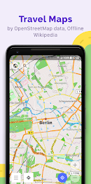
- Map view: Choose from a variety of places to be displayed on the map, such as attractions, food, and health. Easily search for places by address, name, coordinates, or category. Customize the map style to suit your activities, whether it's touring, nautical, winter and ski, topographic, desert, off-road, and more. Enjoy features like shading relief and contour lines.
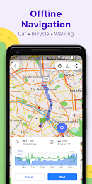
- GPS Navigation: Plan routes to your destination even without an internet connection. The app offers customizable navigation profiles for different vehicles, including cars, motorcycles, bicycles, pedestrians, boats, and public transport. Modify your route to avoid specific roads or road surfaces. Get real-time information about your route, including distance, speed, remaining travel time, and distance to turn.
- Route Planning and Recording: Easily plot a route point by point using various navigation profiles. Record your routes using GPX tracks and manage them on the map. Access visual data about your route, such as descents/ascents and distances. Share your GPX tracks in OpenStreetMap.
- Creation of points with different functionality: Save your favorite places as favorites for easy access. Use markers to mark specific locations. Add audio/video notes to enhance your experience.
- OpenStreetMap: Contribute to the OpenStreetMap community by making edits to the map. Enjoy frequent map updates, with new data available as often as every hour.
- Additional features: Use the compass and radius ruler for added convenience. Access the Mapillary interface for a more immersive experience. Switch to a night theme for better visibility in low-light conditions. Explore Wikipedia articles related to your location. Benefit from a large community of users, extensive documentation, and support.
Conclusion:
With OsmAnd, you can navigate the world offline, making it a reliable and convenient tool for travelers, outdoor enthusiasts, and everyday users. The app offers a wide range of features, including customizable map views, GPS navigation, route planning and recording, creation of points of interest, integration with OpenStreetMap, and additional tools like a compass and Wikipedia integration. Whether you're exploring a new city or embarking on an outdoor adventure, OsmAnd provides the necessary tools to make your journey easier and more enjoyable. Download now to experience the power of offline navigation and mapping.