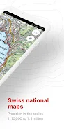
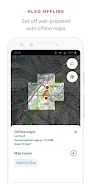
swisstopo brings Switzerland's authoritative cartography to your pocket, combining high-resolution aerial imagery, historical maps and official topographic charts in a single, ad-free app. The swisstopo app supports every scale from 1:10 000 to 1:1 million and offers free offline maps, making it a practical companion for hikers, cyclists, pilots and anyone exploring Swiss terrain. Winner of the "Master of Swiss Apps 2021" award, swisstopo packages drawing and recording tools, route guidance and geodata search so you can plan, navigate and share outings without a login.
Core Functions
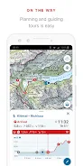
swisstopo lets you access official hiking, mountain and alpine trails, SwitzerlandMobility routes, snowshoe and ski tracks, and public transport stops alongside current aerial images and historical map layers. Offline map coverage ranges from 1:25 000 to 1:1 million. The app supports drawing, recording, importing and sharing tours, and you can set tour types (hiking, cycling, mountain biking) and a personal pace. For aviation needs, swisstopo includes aeronautical charts, obstacle and airspace information, landing sites and noted restrictions for drones and model aircraft.
Key Features
The app is fully free to use: no advertising and no account required. Useful features include a tour guide that shows arrival time and remaining distance, a panorama mode with labelled panorama and 3D views, and the ability to save markers, add notes and share routes with others. Tools for measuring, comparing map layers and searching geographical names, addresses or coordinates help you verify routes and points of interest. Users can also report changes to maps and geodata directly through the app.
User Experience
swisstopo focuses on clarity and practical information: map detail is precise at multiple scales, layers are easy to toggle, and offline downloads make the app reliable in remote areas. Recording and importing tours is straightforward, and the pace-based guidance is helpful for realistic arrival estimates. Panorama and 3D visualisations add geographic context when scouting viewpoints, while measurement and comparison tools assist planning and verification before you set out.
Conclusion
For anyone navigating Switzerland—whether on the ground or in the air—swisstopo delivers authoritative maps and practical navigation tools in a compact, free app. Its combination of offline coverage, official route data and shareable tour features makes it a strong choice for outdoor enthusiasts, transport users and aviation hobbyists who need dependable geographic information without ads or account requirements.